Weather Alert in Maine
Winter Storm Watch issued February 21 at 12:39PM EST until February 24 at 1:00AM EST by NWS Gray ME
AREAS AFFECTED: Interior York; Coastal York; Coastal Cumberland; Strafford; Cheshire; Eastern Hillsborough; Interior Rockingham; Coastal Rockingham; Western And Central Hillsborough
DESCRIPTION: * WHAT...Heavy snow and blowing snow possible. Total snow accumulations greater than 6 inches possible. Winds could gust as high as 45 mph. * WHERE...Portions of southwest Maine and central and southern New Hampshire. * WHEN...From Sunday evening through late Monday night. * IMPACTS...Visibilities may drop below 1/4 mile due to falling and blowing snow. Periods of moderate and heavy snow will combine with low visibility to create dangerous driving conditions. The hazardous conditions could impact the Monday morning and evening commutes. Gusty winds will blow around unsecured objects and break some tree limbs. The power outage threat is limited.
INSTRUCTION: Monitor the latest forecasts for updates on this situation. Persons should consider delaying all travel. Motorists should use extreme caution if travel is absolutely necessary.
Want more detail? Get the Complete 7 Day and Night Detailed Forecast!
Current U.S. National Radar--Current
The Current National Weather Radar is shown below with a UTC Time (subtract 5 hours from UTC to get Eastern Time).

National Weather Forecast--Current
The Current National Weather Forecast and National Weather Map are shown below.

National Weather Forecast for Tomorrow
Tomorrow National Weather Forecast and Tomorrow National Weather Map are show below.

North America Water Vapor (Moisture)
This map shows recent moisture content over North America. Bright and colored areas show high moisture (ie, clouds); brown indicates very little moisture present; black indicates no moisture.

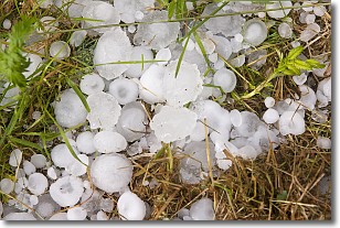
Weather Topic: What is Hail?
Home - Education - Precipitation - Hail
 Next Topic: Hole Punch Clouds
Hail is a form of precipitation which is recognized by large solid balls or
clumps of ice. Hail is created by thunderstorm clouds with strong updrafts of wind.
As the hailstones remain in the updraft, ice is deposited onto them until their
weight becomes heavy enough for them to fall to the earth's surface.
Hail storms can cause significant damage to crops, aircrafts, and man-made structures,
despite the fact that the duration is usually less than ten minutes.
Next Topic: Hole Punch Clouds
Weather Topic: What are Mammatus Clouds?
Home - Education - Cloud Types - Mammatus Clouds
 Next Topic: Nimbostratus Clouds
A mammatus cloud is a cloud with a unique feature which resembles
a web of pouches hanging along the base of the cloud.
In the United States, mammatus clouds tend to form in the warmer months, commonly
in the Midwest and eastern regions.
While they usually form at the bottom of a cumulonimbis cloud, they can also form
under altostratus, altocumulus, stratocumulus, and cirrus clouds. Mammatus clouds
warn that severe weather is close.
Next Topic: Nimbostratus Clouds
Current conditions powered by WeatherAPI.com


