Weather Alert in Alaska
Flood Advisory issued September 1 at 9:48AM AKDT until September 4 at 9:15AM AKDT by NWS Anchorage AK
AREAS AFFECTED: Western Susitna Valley; Central Susitna Valley; Northern Susitna Valley
DESCRIPTION: * WHAT...Flooding caused by excessive rainfall is expected. * WHERE...Northern Susitna Valley in the Petersville area * WHEN...Until 915 AM AKDT Thursday. * IMPACTS...Minor flooding in low-lying and poor drainage areas. Rises in small streams. Some low-water crossings may become impassable. River or stream flows are elevated. * ADDITIONAL DETAILS... - 1 to 3 inches of rainfall is expected today (Monday) into tonight (Monday night). The heaviest rain is expected to occur across the headwaters of Peters Creek and Cache Creek. After a lull in rain on Tuesday, another round of rain set to occur on Wednesday is expected to bring another inch of rainfall. - Area creeks and streams are already running higher than normal after the rainfall from last week. While waters have been receding, additional rainfall may result in rises again this week. - Streams that may be affected include Peters Creek, Cache Creek, Moose Creek, Kroto Creek, and other nearby streams and their tributaries. Larger rivers such as that Yentna and Susitna are NOT expected to rise into flood stage again. - http://www.weather.gov/safety/flood
INSTRUCTION: Stay tuned to further developments by listening to your local radio, television, or NOAA Weather Radio for further information. Turn around, don't drown when encountering flooded roads. Most flood deaths occur in vehicles. Flooding is occurring or is imminent. It is important to know where you are relative to streams, rivers, or creeks which can become killers in heavy rains. Campers and hikers should avoid streams or creeks.
Want more detail? Get the Complete 7 Day and Night Detailed Forecast!
Current U.S. National Radar--Current
The Current National Weather Radar is shown below with a UTC Time (subtract 5 hours from UTC to get Eastern Time).

National Weather Forecast--Current
The Current National Weather Forecast and National Weather Map are shown below.

National Weather Forecast for Tomorrow
Tomorrow National Weather Forecast and Tomorrow National Weather Map are show below.

North America Water Vapor (Moisture)
This map shows recent moisture content over North America. Bright and colored areas show high moisture (ie, clouds); brown indicates very little moisture present; black indicates no moisture.

Weather Topic: What are Shelf Clouds?
Home - Education - Cloud Types - Shelf Clouds
 Next Topic: Sleet
A shelf cloud is similar to a wall cloud, but forms at the front
of a storm cloud, instead of at the rear, where wall clouds form.
A shelf cloud is caused by a series of events set into motion by the advancing
storm; first, cool air settles along the ground where precipitation has just fallen.
As the cool air is brought in, the warmer air is displaced, and rises above it,
because it is less dense. When the warmer air reaches the bottom of the storm cloud,
it begins to cool again, and the resulting condensation is a visible shelf cloud.
Next Topic: Sleet
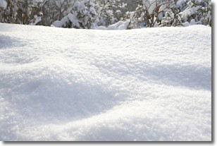
Weather Topic: What is Snow?
Home - Education - Precipitation - Snow
 Next Topic: Stratocumulus Clouds
Snow is precipitation taking the form of ice crystals. Each ice crystal, or snowflake,
has unique characteristics, but all of them grow in a hexagonal structure.
Snowfall can last for sustained periods of time and result in significant buildup
of snow on the ground.
On the earth's surface, snow starts out light and powdery, but as it begins to melt
it tends to become more granular, producing small bits of ice which have the consistency of
sand. After several cycles of melting and freezing, snow can become very dense
and ice-like, commonly known as snow pack.
Next Topic: Stratocumulus Clouds
Current conditions powered by WeatherAPI.com


