Weather Alert in California
Winter Storm Warning issued February 15 at 11:20AM PST until February 19 at 10:00AM PST by NWS Medford OR
AREAS AFFECTED: South Central Siskiyou County; North Central and Southeast Siskiyou County
DESCRIPTION: ...LOW SNOW LEVELS WITH MULTIPLE ROUNDS OF PRECIPITATION... .A sharp cold front will push through the region Monday night into Tuesday morning with a cold air mass to follow through at least Thursday. Snow levels will quickly lower from around 3000 ft during the day Monday to around 1000-1500 ft late Monday night into the early hours of Tuesday. Multiple waves of precipitation will move through the region while this cold air mass is in place, bringing multiple opportunities for low elevation snow. This will be a long duration event, and after the initial front Monday night, precipitation will become more showery, resulting in periods of spotty and quick accumulations. The values reflected below indicate totals over a 72 hour period from 10pm Monday through 10pm Thursday. Daytime heating will result in snow levels rising to around 2000-2500 ft during the daylight hours, then lower back down during the overnight periods. The best chances for accumulating snow down to valley floors will be during the overnight and early morning hours. * WHAT...Heavy snow expected above 5000 ft through Monday morning with accumulations of 4 to 8 inches expected. After a brief lull in precipitation Monday afternoon, snow levels drop to all areas Monday night into Tuesday, and remain low through Thursday. Additional snow accumulations 10 to 15 inches are expected with 1 to 2 ft expected above 4500 ft. Winds gusting as high as 40 mph over high and exposed terrain. * WHERE...Southern and eastern Siskiyou County. This includes Highways 97 and 89, Interstate 5 south of Weed, Black Butte Summit, Snowman Summit, Dead Horse Summit, Grass Lake Summit and Mt Shasta Ski Park Road. This also includes the communities of Mt Shasta City, Dunsmuir, McCloud and Tennant. * WHEN...Until 10 AM PST Thursday. * IMPACTS...Travel may be very difficult to impossible. The hazardous conditions could impact the Monday morning and evening commutes. Gusty winds could bring down tree branches. * ADDITIONAL DETAILS...Snow levels of 5000 feet today are expected to lower to 4500 ft tonight then down to 4000 ft Monday. There could be a period early Monday morning when precipitation intensity brings snow levels down to Mt Shasta City, resulting in accumulating snow along the I-5 corridor. Visit weather.gov/mfr/winter for additional snow probabilities
INSTRUCTION: If you must travel, keep an extra flashlight, food, and water in your vehicle in case of an emergency. Call 511 or visit quickmap.dot.ca.gov for road information.
Want more detail? Get the Complete 7 Day and Night Detailed Forecast!
Current U.S. National Radar--Current
The Current National Weather Radar is shown below with a UTC Time (subtract 5 hours from UTC to get Eastern Time).

National Weather Forecast--Current
The Current National Weather Forecast and National Weather Map are shown below.

National Weather Forecast for Tomorrow
Tomorrow National Weather Forecast and Tomorrow National Weather Map are show below.

North America Water Vapor (Moisture)
This map shows recent moisture content over North America. Bright and colored areas show high moisture (ie, clouds); brown indicates very little moisture present; black indicates no moisture.

Weather Topic: What is Sleet?
Home - Education - Precipitation - Sleet
 Next Topic: Snow
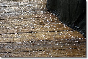
Sleet is a form of precipitation in which small ice pellets are the primary
components. These ice pellets are smaller and more translucent than hailstones,
and harder than graupel. Sleet is caused by specific atmospheric conditions and
therefore typically doesn't last for extended periods of time.
The condition which leads to sleet formation requires a warmer body of air to be
wedged in between two sub-freezing bodies of air. When snow falls through a warmer
layer of air it melts, and as it falls through the next sub-freezing body of air
it freezes again, forming ice pellets known as sleet. In some cases, water
droplets don't have time to freeze before reaching the surface and the result is
freezing rain.
Next Topic: Snow
Weather Topic: What are Stratocumulus Clouds?
Home - Education - Cloud Types - Stratocumulus Clouds
 Next Topic: Stratus Clouds
Stratocumulus clouds are similar to altocumulus clouds in their
fluffy appearance, but have a slightly darker shade due to their additional mass.
A good way to distinguish the two cloud types is to hold your hand out and measure
the size of an individual cloud; if it is the size of your thumb it is generally
an altocumulus cloud, if it is the size of your hand it is generally a
stratocumulus cloud.
It is uncommon for stratocumulus clouds to produce precipitation, but if they do
it is usually a light rain or snow.
Next Topic: Stratus Clouds
Current conditions powered by WeatherAPI.com


