Weather Alert in Montana
Blizzard Warning issued March 11 at 5:53PM MDT until March 12 at 3:00PM MDT by NWS Great Falls MT
AREAS AFFECTED: East Glacier Park Region; Southern Rocky Mountain Front
DESCRIPTION: * WHAT...For the Blizzard Warning, blizzard conditions expected to develop tonight as snowfall rates and wind speeds increase with poorest visibility in periods of moderate to heavy snowfall and strong winds Thursday morning. Wind speeds decrease late Thursday through Friday but periods of light to moderate snowfall will persist through Saturday. Total snow accumulations between 1 and 3 feet are expected by Saturday. Winds gust as high as 70 mph late tonight through Thursday morning. * WHERE...The Continental Divide along the Rocky Mountain Front. * WHEN...For the Blizzard Warning, until 3 PM MDT Thursday. For the Winter Storm Warning, from 3 PM Thursday to 6 PM MDT Saturday. * IMPACTS...Travel could be very difficult or impossible over Marias pass and Rogers pass late tonight through Thursday morning. * ADDITIONAL DETAILS...Whiteout conditions are likely and may make travel treacherous and potentially life-threatening, especially from 12 AM Thursday through 8 AM Thursday.
INSTRUCTION: Remember, a Blizzard Warning means that there is at least an 80% chance of seeing blizzard conditions for at least 3 hours during the warning period. If you must travel, keep an extra flashlight, food, and water in your vehicle in case of an emergency. The latest road conditions can be obtained by calling 5 1 1 or visiting the MDT Road Report website.
Want more detail? Get the Complete 7 Day and Night Detailed Forecast!
Current U.S. National Radar--Current
The Current National Weather Radar is shown below with a UTC Time (subtract 5 hours from UTC to get Eastern Time).

National Weather Forecast--Current
The Current National Weather Forecast and National Weather Map are shown below.

National Weather Forecast for Tomorrow
Tomorrow National Weather Forecast and Tomorrow National Weather Map are show below.

North America Water Vapor (Moisture)
This map shows recent moisture content over North America. Bright and colored areas show high moisture (ie, clouds); brown indicates very little moisture present; black indicates no moisture.

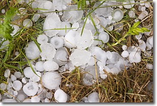
Weather Topic: What is Hail?
Home - Education - Precipitation - Hail
 Next Topic: Hole Punch Clouds
Hail is a form of precipitation which is recognized by large solid balls or
clumps of ice. Hail is created by thunderstorm clouds with strong updrafts of wind.
As the hailstones remain in the updraft, ice is deposited onto them until their
weight becomes heavy enough for them to fall to the earth's surface.
Hail storms can cause significant damage to crops, aircrafts, and man-made structures,
despite the fact that the duration is usually less than ten minutes.
Next Topic: Hole Punch Clouds
Weather Topic: What are Mammatus Clouds?
Home - Education - Cloud Types - Mammatus Clouds
 Next Topic: Nimbostratus Clouds
A mammatus cloud is a cloud with a unique feature which resembles
a web of pouches hanging along the base of the cloud.
In the United States, mammatus clouds tend to form in the warmer months, commonly
in the Midwest and eastern regions.
While they usually form at the bottom of a cumulonimbis cloud, they can also form
under altostratus, altocumulus, stratocumulus, and cirrus clouds. Mammatus clouds
warn that severe weather is close.
Next Topic: Nimbostratus Clouds
Current conditions powered by WeatherAPI.com


