Weather Alert in Oregon
Flood Watch issued March 12 at 12:42AM PDT until March 16 at 10:49PM PDT by NWS Portland OR
AREAS AFFECTED: East Central Willamette Valley
DESCRIPTION: ...The Flood Watch continues for the following rivers in Oregon... Wilson River near Tillamook affecting Tillamook County Coast and North Oregon Coast Range Lowlands zones. Trask River near Tillamook affecting Tillamook County Coast and North Oregon Coast Range Lowlands zones. Johnson Creek at Sycamore affecting Inner Portland Metro zone. Pudding River at Aurora affecting East Central Willamette Valley zone. * WHAT...Flooding is possible. * WHERE...Pudding River at Aurora. * WHEN...From Saturday evening to late Monday evening. * IMPACTS...Above 22.0 feet, expect minor flooding of low-lying agricultural lands and access roads along the river. * ADDITIONAL DETAILS... - At 12:00 AM PDT Thursday the stage was 10.1 feet. - Forecast...Flood stage may be reached based on the latest forecast information. - Flood stage is 22.0 feet. - http://www.weather.gov/safety/flood
INSTRUCTION: Please report observed flooding to local emergency services or law enforcement and request they pass this information to the National Weather Service when you can do so safely. If you are in the watch area, remain alert to possible flooding. Additional information is available at www.weather.gov. The next statement will be issued this morning at 900 AM PDT.
Want more detail? Get the Complete 7 Day and Night Detailed Forecast!
Current U.S. National Radar--Current
The Current National Weather Radar is shown below with a UTC Time (subtract 5 hours from UTC to get Eastern Time).

National Weather Forecast--Current
The Current National Weather Forecast and National Weather Map are shown below.

National Weather Forecast for Tomorrow
Tomorrow National Weather Forecast and Tomorrow National Weather Map are show below.

North America Water Vapor (Moisture)
This map shows recent moisture content over North America. Bright and colored areas show high moisture (ie, clouds); brown indicates very little moisture present; black indicates no moisture.

Weather Topic: What is Fog?
Home - Education - Cloud Types - Fog
 Next Topic: Fractus Clouds
Fog is technically a type of stratus cloud, which lies along the
ground and obscures visibility.
It is usually created when humidity in the air condenses into tiny water droplets.
Because of this, some places are more prone to foggy weather, such as regions
close to a body of water.
Fog is similar to mist; both are the appearance of water droplets suspended in
the air, but fog is the term applied to the condition when visibility is less than 1 km.
Next Topic: Fractus Clouds
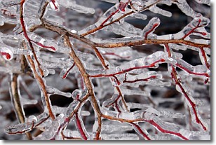
Weather Topic: What is Freezing Rain?
Home - Education - Precipitation - Freezing Rain
 Next Topic: Graupel
Freezing rain is a condition where precipitation which has fallen in the form of
water droplets reaches temperatures which are below freezing and freezes upon
coming into contact
with surface objects. The result of this precipitation is a glaze of ice which
can be damaging to plants and man-made structures. A severe onset of freezing
rain which results in a very thick glaze of ice is known as an ice storm.
Next Topic: Graupel
Current conditions powered by WeatherAPI.com


