Weather Alerts for California
1. Air Quality Alert for: Imperial County Southwest; Chuckwalla Mountains; Imperial County Southeast; Imperial County West; Imperial Valley; Palo Verde Valley
2. Freeze Warning for: Lassen-Eastern Plumas-Eastern Sierra Counties
3. Freeze Warning for: Surprise Valley California; Northern Washoe County
4. Freeze Warning for: Western Siskiyou County; Eastern Curry County and Josephine County; Jackson County
5. Wind Advisory for: Apple and Lucerne Valleys
6. Wind Advisory for: Indian Wells Valley; Mojave Desert
7. Wind Advisory for: Mojave Desert Slopes
8. Wind Advisory for: San Bernardino and Riverside County Valleys-The Inland Empire; San Bernardino County Mountains; Santa Ana Mountains and Foothills; Orange County Inland
9. Wind Advisory for: San Luis Obispo County Beaches; Santa Barbara County Central Coast Beaches
10. Wind Advisory for: Santa Barbara County Interior Mountains; Southern Ventura County Mountains; Northern Ventura County Mountains; Interstate 5 Corridor
11. Wind Advisory for: Santa Barbara County Southwestern Coast; Santa Ynez Mountains Western Range; Santa Ynez Mountains Eastern Range
12. Wind Advisory for: Santa Clarita Valley; Ventura County Beaches; Ventura County Inland Coast; Central Ventura County Valleys; Western Santa Monica Mountains Recreational Area; Calabasas and Agoura Hills; Western San Fernando Valley; Southeastern Ventura County Valleys; Santa Susana Mountains
13. Wind Advisory for: Santa Lucia Mountains
14. Wind Advisory for: South-Central Shasta County Including Redding Metro; Northern Sacramento Valley in Tehama County; Central Glenn County Including Interstate 5; Eastern Glenn County; Butte County Below 1000 ft; Central Colusa County Including Interstate 5; Eastern Colusa County; Sutter and Yuba Counties Below 1000 ft; Capay Hills of Yolo County and Vaca Hills of Solano County; Western Yolo County Including Capay Valley and Interstate 505; Central Yolo and Northeast Solano Counties Including Woodland and Davis; Sacramento Metro and Western El Dorado and Amador Counties; Central Solano County Including Fairfield and Vacaville; Southwestern Solano County Including Vallejo; Sacramento County Delta; San Joaquin County Delta
15. Wind Advisory for: Western San Gabriel Mountains and Highway 14 Corridor; Eastern San Gabriel Mountains
Want more detail? Get the Complete 7 Day and Night Detailed Forecast!
Current U.S. National Radar--Current
The Current National Weather Radar is shown below with a UTC Time (subtract 5 hours from UTC to get Eastern Time).

National Weather Forecast--Current
The Current National Weather Forecast and National Weather Map are shown below.

National Weather Forecast for Tomorrow
Tomorrow National Weather Forecast and Tomorrow National Weather Map are show below.

North America Water Vapor (Moisture)
This map shows recent moisture content over North America. Bright and colored areas show high moisture (ie, clouds); brown indicates very little moisture present; black indicates no moisture.

Weather Topic: What are Cirrostratus Clouds?
Home - Education - Cloud Types - Cirrostratus Clouds
 Next Topic: Cirrus Clouds
Cirrostratus clouds are high, thin clouds that form above
20,000 feet and are made mostly of ice crystals. They sometimes look like giant
feathers, horse tails, or curls of hair in the sky.
These clouds are pushed by the jet stream and can move at high speeds reaching
100 mph.
What do they indicate?
They indicate that a precipitation is likely within 24 hours.
Next Topic: Cirrus Clouds
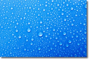
Weather Topic: What is Condensation?
Home - Education - Precipitation - Condensation
 Next Topic: Contrails
Condensation is the process which creates clouds, and therefore
it is a crucial process in the water cycle.
Condensation is the change of matter from a state of gas into a state of liquid,
and it happens because water molecules release heat into the atmosphere and
become organized into a more closely packed structure, what we might see as
water droplets.
Water is always present in the air around us as a vapor, but it's too small for
us to see. When water undergoes the process of condensation it becomes organized
into visible water droplets. You've probably seen condensation happen before on the
surface of a cold drink!
Next Topic: Contrails
Current conditions powered by WeatherAPI.com


