Weather Alerts for Idaho
1. Avalanche Warning for: Bonner, ID; Boundary, ID; Shoshone, ID
2. High Wind Warning for: Arco/Mud Lake Desert; Upper Snake River Plain; Southern Hills/Albion Mountains; Teton Valley
3. High Wind Warning for: Coeur d'Alene Area; Idaho Palouse; Northeast Blue Mountains; Lower Garfield and Asotin Counties; Washington Palouse; Moses Lake Area; Upper Columbia Basin; Spokane Area; Waterville Plateau
4. High Wind Warning for: Lower Snake River Plain
5. High Wind Warning for: Northern Panhandle; Central Panhandle Mountains; Northeast Mountains; Okanogan Highlands
6. High Wind Warning for: Western Lemhi County; Eastern Lemhi County
7. High Wind Watch for: Upper Treasure Valley; Southwest Highlands; Owyhee Mountains; Harney County; Baker County; Malheur County
8. High Wind Watch for: Western Magic Valley; Camas Prairie; Southern Twin Falls County
9. Hydrologic Outlook for: Clearwater, ID; Idaho, ID
10. Wind Advisory for: Beaverhead/Lemhi Highlands; Lost River Valleys; Challis/Pahsimeroi Valleys
11. Wind Advisory for: Lewiston Area; Lewis and Southern Nez Perce Counties
12. Wind Advisory for: Orofino/Grangeville Region; Lower Hells Canyon/Salmon River Region
13. Wind Advisory for: Shoshone/Lava Beds; Eastern Magic Valley; Raft River Region; Marsh and Arbon Highlands; Blackfoot Mountains
14. Wind Advisory for: Western Magic Valley; Camas Prairie; Southern Twin Falls County
15. Winter Storm Warning for: Central Panhandle Mountains
16. Winter Storm Warning for: Northern Clearwater Mountains
17. Winter Storm Warning for: Southern Clearwater Mountains
18. Winter Weather Advisory for: Idaho Palouse; Washington Palouse
19. Winter Weather Advisory for: Lewis and Southern Nez Perce Counties
Want more detail? Get the Complete 7 Day and Night Detailed Forecast!
Current U.S. National Radar--Current
The Current National Weather Radar is shown below with a UTC Time (subtract 5 hours from UTC to get Eastern Time).

National Weather Forecast--Current
The Current National Weather Forecast and National Weather Map are shown below.

National Weather Forecast for Tomorrow
Tomorrow National Weather Forecast and Tomorrow National Weather Map are show below.

North America Water Vapor (Moisture)
This map shows recent moisture content over North America. Bright and colored areas show high moisture (ie, clouds); brown indicates very little moisture present; black indicates no moisture.

Weather Topic: What are Contrails?
Home - Education - Cloud Types - Contrails
 Next Topic: Cumulonimbus Clouds
A contrail is an artificial cloud, created by the passing of an
aircraft.
Contrails form because water vapor in the exhaust of aircraft engines is suspended
in the air under certain temperatures and humidity conditions. These contrails
are called exhaust contrails.
Another type of contrail can form due to a temporary reduction in air pressure
moving over the plane's surface, causing condensation.
These are called aerodynamic contrails.
When you can see your breath on a cold day, it is also because of condensation.
The reason contrails last longer than the condensation from your breath is
because the water in contrails freezes into ice particles.
Next Topic: Cumulonimbus Clouds
Weather Topic: What are Cumulus Clouds?
Home - Education - Cloud Types - Cumulus Clouds
 Next Topic: Drizzle
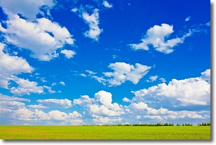
Cumulus clouds are fluffy and textured with rounded tops, and
may have flat bottoms. The border of a cumulus cloud
is clearly defined, and can have the appearance of cotton or cauliflower.
Cumulus clouds form at low altitudes (rarely above 2 km) but can grow very tall,
becoming cumulus congestus and possibly the even taller cumulonimbus clouds.
When cumulus clouds become taller, they have a greater chance of producing precipitation.
Next Topic: Drizzle
Current conditions powered by WeatherAPI.com


